
With a few days of recovery under the belt from the flights from one side of the world to the other in 40 hours, the family decided to assemble for my first weekend home and have a reunion. Mum, all 5 children and their partners, 8 of the 9 grand children and 3 of the 6 great grand children managed to make it, 22 in all. Those first few days home were warm and pleasant however the day after the reunion it began to rain and it did not stop. It continued for another 4 days. Rain like I had not seen outside the tropics, with 110mm in one day. It seemed ridiculous to be getting this much rain at a time when 90% of New Zealand was baking under extreme temperatures and suffering droughts. In the far north they had even run out of water in one council area and were having to ship it in.
My home town of Gore is a rural service town of approximately 13 000 on the plains of the southern most province of New Zealand, Southland. Gore is best known as the Capital of New Zealand Country Music and the site of illicit whiskey distilling in the surrounding Hokonui hills (Hokonui Whiskey) from the 1870s until as late as the 1950s during prohibition. It straddles one of the major Southland rivers, the mighty Mataura. The river dissects the town into 2 halves with my mother, one of my brothers and one of my sisters on eastern side (East Gore), and my other sister on the western side (Gore Main).

We began to suspect on the 3rd day of rain that things were beginning to look a little dicey. That night one of the smaller rivers, the Waikaka River, feeding into the Mataura just south of Gore burst its banks and began to flood an industrial area of the town. My sister’s partner’s workplace went under within a few hours. Later on that Wednesday night the first civil defence alarm went off around 9 pm (exactly a week after my arrival). The alarm asked us to pack & prepare for evacuation. Where we were at my younger sister’s, we were up on the side of the hill so there was no risk of flooding but there was a risk of getting cut off from everything else. The main arterial route through New Zealand, State Highway 1 was cut off just north of the town so things were going from bad to worse. We immediately began storing water, finding all the necessary articles, batteries, gas bottles etc. before heading off to bed.


The first I heard was my sister being called out at 4.15 in the morning. She manages a local supermarket and the Civil Defence Authority were wanting to collect all the fresh bread, milk and other necessities for the evacuation centres they were beginning to build up. Then at 6.14 my telephone began screaming an emergency message to evacuate. A decision was made to move to my mother’s & brother’s who were high up on a terrace overlooking the river where we would have access to my brothers emergency generators and gas barbecue. My sister arrived home about that time to get clothes and necessities. Her supermarket was on the other side of the river to us and there was a risk if the river continued to rise they would close the bridge and she would be stranded on the other side. She also informed me, my other sister & her husband on the lower side of Gore had been evacuated as the river was at risk of breaching its banks and they were in the flood zone if it went. The floods of 1978 and 1987 had inundated that area.


Having moved to my mother’s, I went through her emergency gear and for the most part we were well prepared with the exception of having no means to cook. At around 8.30am we were informed they would be closing the bridge between the two sides of the town and the power & water supplies would be switched off to protect the generators & pumps. Unfortunately, we had gone for a walk to see how high the waters had arisen around the terrace we were on and had failed to boil water and put in thermoses for coffee & tea. Fortunately, my brother lived only a hundred metres away and had a gas BBQ so we could heat water and cook if needed.
Here are two links to videos of the flood water (just click on the link):
As we wandered the perimeter of the terrace above the river where my mother lives, it became apparent that the volume of water surrounding us and the speed at which it was moving was going to equate to the floods of 1978 & 1987, if not worse. The first day I was home I had wandered along the flood bank (levee) of the river in the beautiful sunshine and commented on how low the river was and that you could almost walk across it. I happened to take a panoramic picture of the river on that first day so I continued take a series of panoramic pics from the same spot over the coming 36 hours as the river rose and then fell. Here they are.
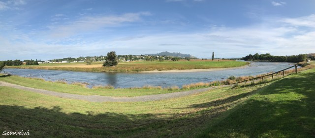
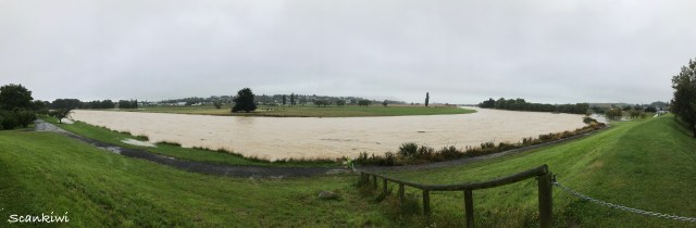
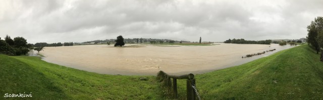
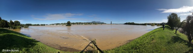
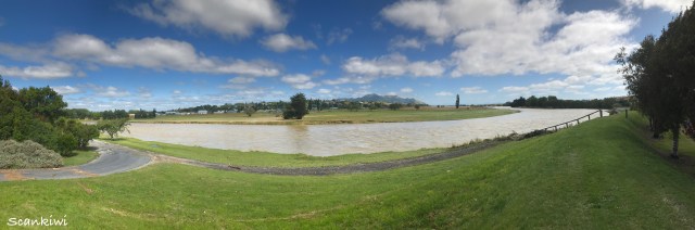
While standing on the flood bank I could compare the water levels on one side to the ground level on the other. At one point the water level of the river was 2-3 metres higher than the ground level on the other side the flood bank. If the flood bank didn’t hold the houses on the other side would be gone in a tsunami of water. It was of considerable concern to the emergency organisation as this flood bank was on a corner in the river and was taking the brunt of the upstream pressure of the flood waters. Here are pictures of the houses behind the flood bank.


At one point the town centre on the other side was at risk of flooding as the flood waters from the river were beginning to back up through the storm water system and pop the manhole covers in the streets. Immediately, they began sandbagging the shops and businesses to prevent flooding. My sister was evacuated out of the supermarket to higher ground as they were concerned the water levels could overwhelm them in minutes if the banks went. All the meanwhile helicopters were flying backwards and forwards over the town. Some part of the emergency teams and others part of the news crews. The views they were sending back to the ground were both spectacular and scary. The red area on the map went under first. The green and orange areas were evacuated but did not flood, while the rest of the area flooded. The little plateau above the red area was the terrace we were on. At the bottom tip of that terrace is the bridge across the river.


Other parts of the southern region were also hammered with Fiordland in the west taking the brunt of it. Fiordland is where the headwaters of most of the Southland rivers originated including the Matarua running through Gore. The main road into one of our major tourist attractions, Milford Sound, suffered badly and will probably be out with only limited access until after the winter. The devastation can be witnessed in the photos below. The force of the water must have been tremendous to rip the road like that.


About 12 kilometres south of Gore along the Mataura river is the township of Mataura with its meat works and old paper mills on the banks of the river at what is called the Mataura falls, where the river drops vertically about 10 metres. When it flooded the falls disappeared and the water lapped the walls of these factories. Housed inside the old paper mills was toxic dross from the local aluminum smelter further south. A one point they emergency services were extremely concerned that the factory would be flooded. If the dross was to get wet it would release toxic ammonia fumes and would be a deadly risk for all those in the vicinity. At one point my nephew was in the building sandbagging the wall against the river to strengthen it. Crazy! The photos below show the river in normal flow and when it was in flood. The red brick building is the old paper mill.


As the river heads south it eventually reaches the estuary on the southern coast at Fortrose. This is a tidal estuary where the water levels can rise and fall 2-3 metres with each tide. The volume of water flowing in the river meets this estuary and if the tide is on the way out it flows out to sea. But if the tide is on the way in, it backs the water up acting like a damn and causes it to spill out over the low lying farmland in the area of Wyndham. With the sea tides on a 12 hour cycle between high tides it meant that under the 36 hours the river was in high flood that it pushed to water out over the low lying farmlands at least 3 times.

Thirty six hours after the chaos began, the rain stopped, the rivers dropped and the sun came out. Now was there was a massive clean up to take care of. The best thing was the flood bank below us held and the houses behind it were saved. As the flood waters receded the damage to the roads, buildings and businesses became apparent. Then began the big clean up that would take days, weeks and in some places months to complete. I spent the next couple of days helping my sister cook and deliver food to those doing the clean up.


My brother works with water systems for local farmers. We made visits to several farms to inspect damage to their pumping systems which are usually located on the river banks transferring water from the river out over the farm. There were not many places we visited where the pumps and their electrical systems had not been under water, and in some places under several metres of water. Even the roads at some points were washed out or piled high with river gravel.


The Gore and Mataura River areas will be cleaning up and recovering from this over the next few months. It will be remember as one of the big floods just like the 1978 and 1987 floods which I remember well.
